One of the major railroad projects undertaken during the 19th and 20th centuries is the Ojinaga-Topolobampo line, notable for both its contribution to the economic development of Mexico and for bearing witness to the ability of Mexican engineering to resolve location, project and construction issues posed by the complex conditions of the terrain along the route.
The planning for the development of the Mexican railroad system needed to take into account connecting regions that have high production and consumption of items that can be transported in large volumes over long distances.
This is one of the reasons the Ojinaga-Topolobampo line achieved the goals of the Mexican government, which made a significant investment in this project to connect the central northwest of Mexico with the Pacific coast completing the line in 1961.
Even at the end of the 19th century, many people were thinking about the importance of a railway line. But it wasn’t until 1861 when Albert Kinsey Owen came to Mexico as a railroad engineer and while traveling along the Pacific coast he reached Oguira Bay “Enchanted Place”, in the local Cahitan language, today known as Topolobampo.
Owen thought this would be the perfect place for his dream of forming a Mexican-US company and building a railroad that would connect the US mid-west and his recently discovered bay. In 1863, Owen presented his idea at a meeting with the US Congress and governors, but he was not successful.
From 1875 to 1879, Owen focused solely on promoting his idea and proposed various public projects to the Mexican government.
He was finally able to obtain a concession to build a railroad between Piedras Negras and Topolobampo, with branch lines to Mazatlan, Alamos and Presidio del Norte (today, the city of Ojinaga, Chihuahua).
STAGES OF CONSTRUCTION
After changing hands various times, Foster Higgins acquired the concession and formed the company Ferrocarril del Río Grande, Sierra Madre y Pacífico, which in 1897 built the Ciudad Juarez – Corralitos line in the state of Chihuahua, and the following year completed another section to Casas Grandes, a total of 259 kilometers (161 miles).
It was Enrique Creel and Alfredo Spendlove who acquired the concession in 1897 to build and operate a line from Chihuahua to anywhere on the Pacific. Their company, “Chihuahua al Pacífico”, built 194 kilometers (120.5 miles) of track in the state of Chihuahua, from the capital to the community of Minaca.
With a new decree, the US company Kansas City, México y Oriente was created, which built the 88 kilometer (55 mile) La Junta – Temosachic line in Chihuahua and the Topolobampo – San Pedro line in Sinaloa between 1902 and 1908.
The first formal attempt to build a railroad between the United States and the Pacific coast was made by Stillwell, an important businessman who believed the project would attract cargo traffic from the coast to the US mid-west through a shorter railroad line: Kansas City – Topolobampo.
But it was during the Mexican revolution that the companies were able to complete various lines. From 1910 to 1914, Ferrocarril del Noroeste finished the Temosachic-Casas Grandes line; the Kansas railway, under different leadership, completed the Chihuahua-Ojinaga section; and lastly, Enrique Creel’s Chihuahua al Pacífico railroad built the Chihuahua-Creel section.
In 1940, the Mexican government acquired the rights from the Kansas City, México and Oriente Railroad Co., and in May 1952 took possession of the line operated by The Mexican Northwestern Railway Co., merging the two companies in 1955 to form Ferrocarril Chihuahua al Pacifico, S.A. de C.V.
THE GREAT CHALLENGE
The last, and most complicated, section was the 258 kilometers (160 miles) from the Creel station in Chihuahua to Heriberto Valdez (San Pedro) in Sinaloa, crossing through the heart of the Western Sierra Madre Mountains, which the Mexican government completed and opened on November 24, 1961 as Ferrocarril Chihuahua al Pacifico. In addition to the $1.133 billion pesos invested up to June 30, 1961 in the construction and reconstruction of this line, the project took enormous technical and human efforts to overcome the obstacles of the imposing Tarahumara Mountains.
MERGER
On June 11, 1987, by Presidential Decree published in the Official Federal Gazette, the Ferrocarril Chihuahua al Pacífico railway became part of Mexico’s national railroad system (Ferrocarriles Nacionales de México).
PRIVATIZATION
On June 22, 1997, the Mexican government, through the Ministry of Transport and Communications, awarded Ferrocarril Pacífico- Norte, S.A. de C.V. a 50 year concession to operate the Pacific-North trunk line and the Ojinaga-Topolobampo (Chihuahua-Pacific) short line. The concession did not include the La Junta-Nuevo Casas Grandes, Chihuahua branch line, which was then cancelled. The Ciudad Juarez-Corralitos section was cancelled in 1993 because it was not productive for the Mexican government. Grupo Ferroviario Mexicano, S.A. De C.V. acquired the concession on December 4, 1997, changing the company name to Ferrocarril Mexicano, S.A. De C.V., starting operations on February 19, 1998.
Chihuahua – Pacific (Q Line)
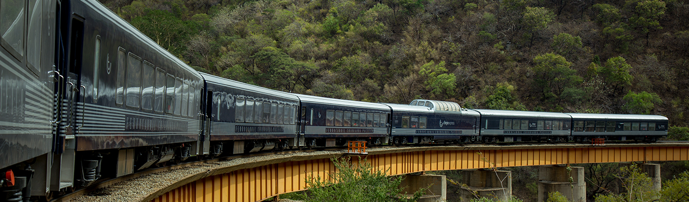
Railroad lines are assigned a letter to differentiate one route from another. The Ojinaga-Topolobampo short line is known as the Q Line. This line starts in Ojinaga, Chihuahua, which borders the state of Texas at Presidio, and ends at the port of Topolobampo, in the Gulf of California, Sinaloa. The Q line is 941 kilometers (585 miles) long, crossing 268 kilometers (167 miles) of semi-desert, 653 kilometers (405 miles) of farmlands, mountains, ravines and canyons, with small picturesque communities scattered along the route, completing the last 20 kilometers (12.5 miles) of the journey at sea level.
OVERVIEW
To get a sense of the enormity of this railroad project, 86 tunnels were drilled and built, of which only 22 are false (not drilled into the mountain or drilled into the mountain and reinforced with concrete), totaling 18 kilometers (11.2 miles) in length. There are also 175 bridges on the route, comprised of different types of structures totaling 5.0 kilometers (3.1 miles) in length, 37 of which are particularly noteworthy, some using pre-stressed concrete for the first time in Mexico. Additionally, the railroad successfully managed to cross a landscape of exceptional beauty to connect points of development and production, and offering an option for transporting large volumes of freight from the US mid-west to the Pacific coast, and vice versa. Over a relatively short route, the railroad serves livestock, farming forestry and mining production areas, while also contributing to developing tourism in the north of Mexico.
NOTABLE ENGINEERING WORKS ON THE CHIHUAHUA-PACIFIC ROUTE
1) KM. Q-562.- “Continental” Tunnel. 1,260 meters (4,135 feet) in length. Gets its name because the tunnel crosses the Western Sierra Madre watershed.
2) KM. Q-592.- “El Lazo”. Split-level crossing because of the gradient.
3) KM. Q-639.- “La Laja” Bridge. Built with pre-stressed concrete beams and thin piles up to 50 meters (165 feet) high. This 155 meter (508 foot) bridge was the first in Mexico to be built with pre-stressed concrete beams.
4) KM. Q-707.- “Temoris”. Three-tier development on the line involving bridges, viaducts and tunnels, highlighting the “Santa Barbara” bridge, 217 meters (712 feet) long on a curve and the 937 meter (3,075 foot) “La Pera” tunnel, whose name describes its form.
5) KM. Q-710.- “Frankenstein” False Tunnel. This 200 meter (650 foot) tunnel was the longest of its type at the time it was built.
6) KM. Q-748+282.- “Chinipas” Bridge. At 234 meters (765 feet) long and 102 meters (335 feet) high, this bridge is the highest on the Q line.
7) KM. Q-779+881.- “Aguacaliente” Bridge. Crossing the El Fuerte River and at 45 meters (150 feet) high and 498.5 meters (1,635 feet) long, this is the longest bridge on the route.
8) KM. Q-754+600.- “El Descanso” Tunnel. One of the longest on the route at 1,838 meters (1.15 miles). When it was built, this tunnel was the longest in Mexico.
PLACES OF INTEREST
Chihuahua-Anahuac Line- A large portion of the line follows the Santa Isabel River, traveling through farming areas and the town of San Andres (today, Riva Palacio). General Francisco Villa married Luz Corral here. Anahuac, Chihuahua- Bustillos Lake is found here, as well as apple, farming and livestock production.
Cuauhtemoc, Chihuahua- Has the same production industries as Anahuac and is the local mining center. There are many Mennonite communities here, with strong farming and dairy production.
La Junta, Chihuahua- (today, Lopez Mateos). Town that was created with the railroad. The oldest and largest railway workshops of the Chihuahua-Pacific are here, although no longer in use. This area is known for farming, apple production and livestock.
San Juanito, Chihuahua- Community known for its forestry production. This is the coldest place in Mexico, recording temperatures of up to 23°C below zero (-9.5ºF).
Creel, Chihuahua- For more than fifty years this was the end of the line, until 1961. There are many hotels here offering tours to major tourist attractions, like Arareco Lake, the Cusarare Waterfall, valleys with rock formations, canyons, the town of Batopilas and the Basaseachi Waterfall.
El Lazo- Km. Q-592. To manage the slope and give continuity to the line of the track, the train doubles back on itself, first crossing the bridge, then passing under it through a tunnel.
Divisadero, Chihuahua- Km. Q-622. There is a lookout point here, high above the Copper Canyon from which you can see part of the Urique Canyon, formed by the Urique, Del Cobre, Batopilas, Oteros, Tararecua and Sinforosa Canyons. Together, these canyons are spread over 1,500 kilometers (932 miles) making them four times bigger than the Grand Canyon in the United States.
Temoris, Chihuahua- Place of great beauty for its high and rugged mountains. The construction of the line at this point is the greatest feat of engineering on the route, as described above.
In summary, to talk about the Chihuahua-Pacific route is to talk about its amazing and bold engineering, the canyons, great mountains, forests and ravines. This region frequently serves as the backdrop for stories, films, documentaries, major newspaper articles, magazines and television networks, who come here from all over the world, attracted by the charm of the rustic countryside and the majesty of the railroad.